


DIGIPIN: Revolutionizing Addressing in India with a Digital Edge

India is embarking on a significant transformation in its addressing system with the introduction of DIGIPIN, the Digital Postal Index Number.
Developed by the Department of Posts in collaboration with IIT Hyderabad and NRSC, ISRO, DIGIPIN is an open-source, nationwide, geo-coded addressing system poised to enhance everything from last-mile delivery to emergency response and governance.

What is DIGIPIN?
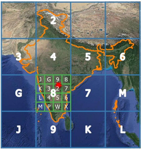
At its core, DIGIPIN is a novel addressing solution that divides the entire geographical area of India, including its maritime regions, into approximately 4-meter by 4-meter grids. Each of these grids is assigned a unique 10-character alphanumeric code, derived directly from its precise latitude and longitude coordinates. Unlike traditional postal PIN codes which identify broader areas, DIGIPIN offers a highly precise, location-specific identifier for every 4x4 meter square.
This system is a key component of the Indian government's "DHRUVA" (Digital Hub for Reference and Unique Virtual Address) initiative, which envisions a standardized, interoperable, and geocoded digital addressing system supporting secure and seamless sharing of address information. It's an "Address-as-a-Service (AaaS)" paradigm, recognizing address information as a foundational public infrastructure vital for effective governance and inclusive service delivery.

How does DIGIPIN work?
The 10-character alphanumeric DIGIPIN code is an encoded representation of a location's exact latitude and longitude. The system employs a hierarchical partitioning method, where the initial characters define larger regions, and subsequent characters narrow down the location to the 4x4 meter grid. This design provides inherent directionality and adjacency, allowing for logical navigation and location identification even offline.

Crucially, DIGIPIN does not store any personal data. It solely provides a location code based on geographic coordinates, ensuring user privacy. The Department of Posts has also made the technical documentation and conversion logic open-source, promoting widespread adoption and integration. Users can find their DIGIPIN through a dedicated web application by providing their geolocation or latitude/longitude coordinates.
The Transformative Benefits of DIGIPIN
The introduction of DIGIPIN promises a multitude of benefits across various sectors:
- Enhanced Location Accuracy: By providing precise geographic coordinates down to a 4x4 meter square, DIGIPIN significantly improves the accuracy of location identification, which is critical for a diverse country like India with often complex or informal addressing systems.
- Improved Last-Mile Delivery: For e-commerce and logistics companies, DIGIPIN can drastically reduce delivery failures and optimize routing, especially in rural or remote areas where traditional addresses might be vague or non-existent.
- Faster Emergency Response: In emergency situations, such as medical crises or natural disasters, DIGIPIN can enable emergency services to pinpoint exact locations quickly, leading to faster and more effective aid.
- Streamlined Government Services: Government welfare schemes, ration distribution, and public service delivery can be made more efficient and targeted, reaching beneficiaries even in areas lacking formal addresses.
- Boost to Financial Inclusion: Financial institutions, fintech companies, and telecom providers can leverage DIGIPIN for more accurate and efficient KYC (Know Your Customer) verification processes, reducing fraud and expanding access to services.
- Smarter Urban Planning: For urban development and infrastructure planning, DIGIPIN offers a standardized geospatial reference system that can aid in land management, municipal services, and data-driven decision-making.
- Accessibility and Inclusivity: DIGIPIN is designed to be universal, providing an address for every location, including forests, oceans, and places without traditional street names or house numbers, thereby fostering greater inclusivity.
- Permanency and Stability: Unlike traditional addresses that can change with new developments or re-naming of streets, a DIGIPIN remains constant, providing a permanent digital identifier for a specific geographic point.

DIGIPIN and the Future
DIGIPIN represents a crucial leap in India's digital public infrastructure. By providing a robust, open-source, and privacy-conscious digital addressing system, it lays the groundwork for numerous innovations across public and private sectors. While traditional postal addresses will continue to exist, DIGIPIN acts as a powerful complementary layer, enhancing precision, efficiency, and accessibility in an increasingly digital world.
As the DIGIPIN ecosystem expands and integrates with various GIS systems, it is set to redefine how India navigates, delivers, and governs, ultimately contributing to a more connected and efficient nation.
Please sign in
Login and share